
Black Mountain's Past
Where history meets the headwaters of the Catawba River
Wendell Begley
Guest contributor
The Valley Echo
January 25, 2024
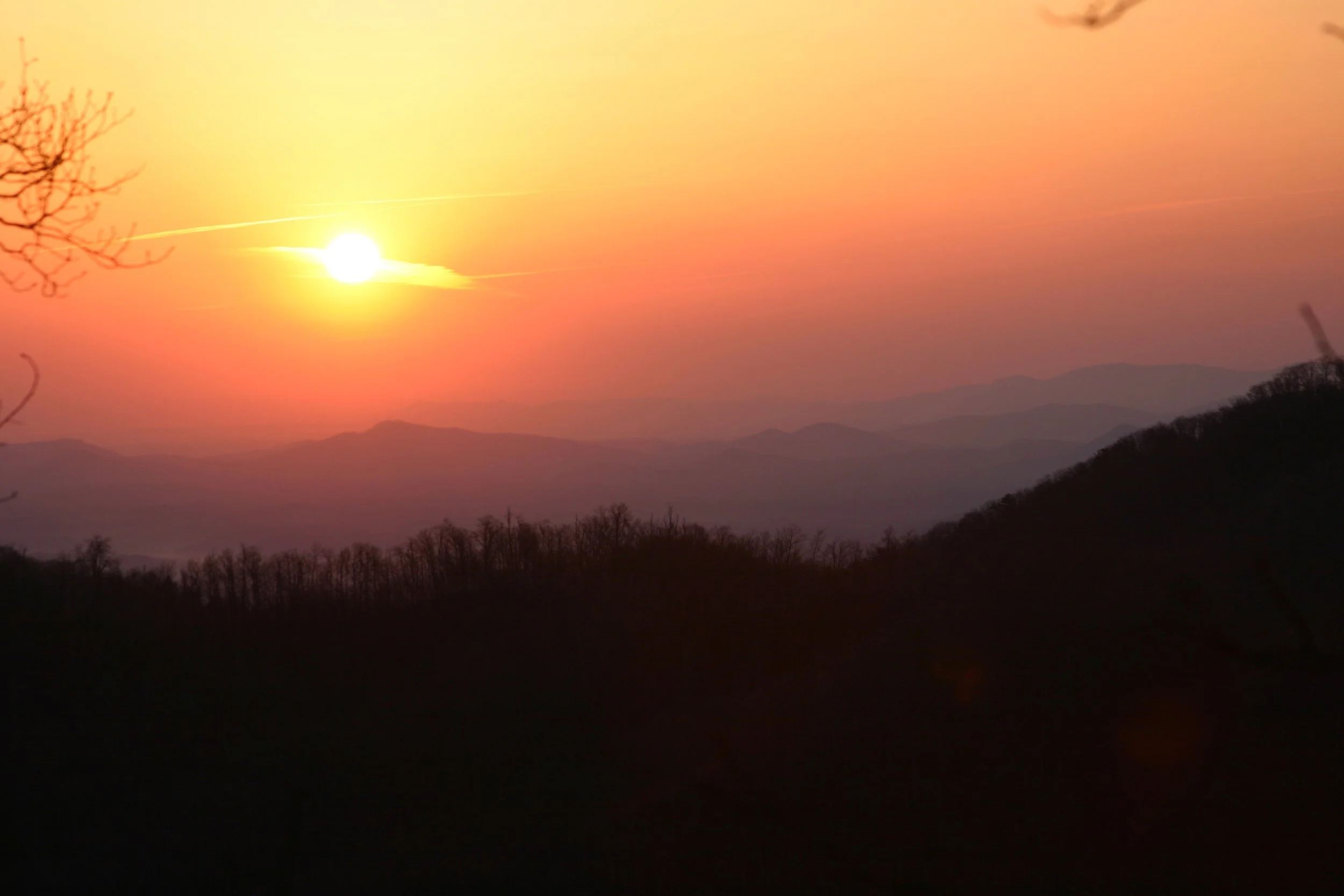
Spring sunrise over the Old Cherokee Boundary along the Swannanoa Rim and uppermost Catawba Headwaters. Photo by Wendell Begley
This week’s series highlights the most remote section of the Swannanoa Rim, located along the Eastern Continental Divide. The same prominent ridgeline is also known as the Old Historic Cherokee Boundary, running along the crest of the Blue Ridge Range in a southwest to northeast direction. To feature the respective border, I have included a 2004 sunrise taken from my back porch (above) at the head of Camp Branch. Along this prominent, 3-mile section of the Rim, stretching from Evans Knob to Ridgecrest’s Swannanoa Gap, a kaleidoscope of human events have played out. For it was here that our earliest pioneers crossed the high, legendary Cherokee Boundary and entered the Swannanoa Valley.
On Saturday, May 7, the Swannanoa Valley Museum sponsored the third Rim Hike of the 2016 Series. The bushwhacking adventure included the trailless segment of ridgeline mentioned above. This section of the Swannanoa Rim, along the Continental Divide, separates the headwaters of the Swannanoa and Catawba Rivers. In the past seven years of guiding folks along this amazing wilderness corridor, over 300 adventurers have witnessed the true beauty and isolation that is characteristic of the upper Catawba’s headwaters, especially in springtime.

One of the most thrilling rewards these wilds bring about is the opportunity to take folks to the very source of the Catawba River. Surprisingly, North Carolina’s largest and most urbanized river, the Catawba, bubbles right out of the ground in the deep wilderness beneath the Swannanoa Rim. I have included an early morning picture of the day 44 souls adventured off the sharp ridgeline and into the hidden cove that harbored this geographical wonder of North Carolina history (above).
As a young boy growing up at the foot of Sunset Mountain—the big pyramid shaped mountain looming on the town’s southeast horizon—I developed a deep passion for the outdoors and was drawn to the wilds of the nearby high plateau of the upper Catawba River headwaters. Back then, I knew the Catawba’s deep forest as the “big wilderness” far beyond my home at the foot of Sunset Mountain. The backwoods destination usually took me the better part of a day’s hiking to get there and back before dark. Most importantly, in the fall of the early 1960s, the trackless boundary harbored some of the best squirrel hunting I could walk to.
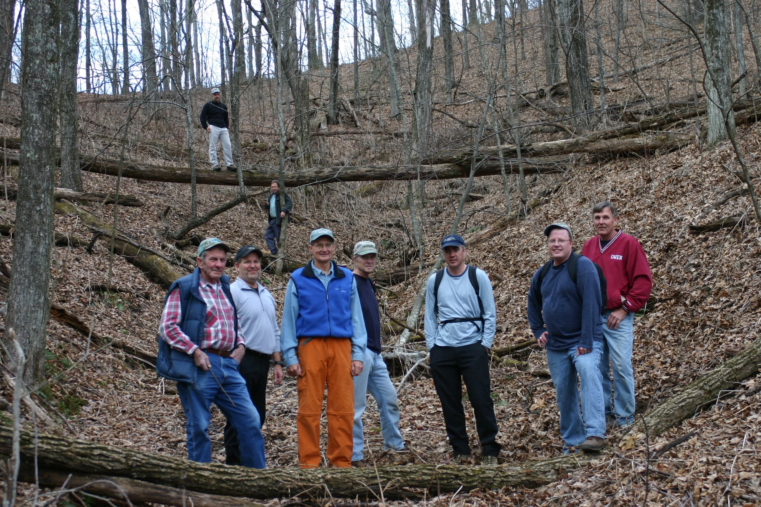
This 2004 photo was taken at the “Hanging Bog” on the northeast side of John Buckner Knob in the upper Catawba headwaters. Included in the picture, left to right are: Monie Sneed, Wendell Begley, Roger Hibbard, John Buckner, Chip Craig, Jim Halverson, Tom Jones. In the background are Van Burnette and Clay Hile (on the log). Photo courtesy of Wendell Begley
Oh, how time can be truly fateful. Today, I live at the terminus of that same long ridgeline (behind Sunset Mountain) that I once walked and hunted as a young boy. Fortunately, from my backdoor, it is only a short hike to the upper Catawba wilderness boundary. Since those adventurous years of youth, I continue to hike the upper Catawba River Gorge. Springtime is my favorite time to visit the high, trackless wilderness. With the sun warming the mountainside, green is the color of the day. The rugged wilderness is unsurpassed in beauty, especially as the green of the season moves up the highest ridges. The pristine coves are alive with trillium and full-running streams.

One of the NC’s most spectacular and pristine deep wilderness waterfalls. Photo by Wendell Begley
The most spectacular physical feature in the entire upper Catawba wilderness is Catawba Falls (above). Without question, the majestic free-falling waterfall is deservedly known as one of North Carolina’s most remarkable, deep wilderness waterfalls. As many times as I have visited the site, I’ll never tire of the sound of the roaring abyss, the crystal-clear water pooled at the bottom of the falls and the blowing cold spray that peppers my face. It is a “wild place” and one burnt deep into my memory.
Fortunately, a trek today into the rugged wilds of the upper Catawba looks much as it did well over two- and one-half centuries ago when the warring tribes of the Catawba and Cherokee competed for hunting rights in the adjoining deep forests, coves and river valleys.
It is indeed ironic that North Carolina’s most populated and controlled river begins as a virgin trickle in an obscure, trackless cove behind Black Mountain’s historic Sunset Mountain. I have enjoyed sharing with readers a few memorable photographs of my springtime visits along the Swannanoa Rim and into the deep wilds of the upper Catawba wilderness. It is truly a place of legends, history and stirring memories. Cheers!
Black Mountain Savings Bank
P.O. Box 729 • 200 East State Street • Black Mountain, NC 28711 • 1.828.669.7991
“We are One of America's Oldest FDIC Insured Banks, Specializing in Home Loans and Savings Deposits in the Valley for Over 100 Years."
Copyright: M. Wendell Begley, series 860, VE5, January 26, 2024
